103-FR-RueDesGrandes-3Legs (gpx)
Send download link to:
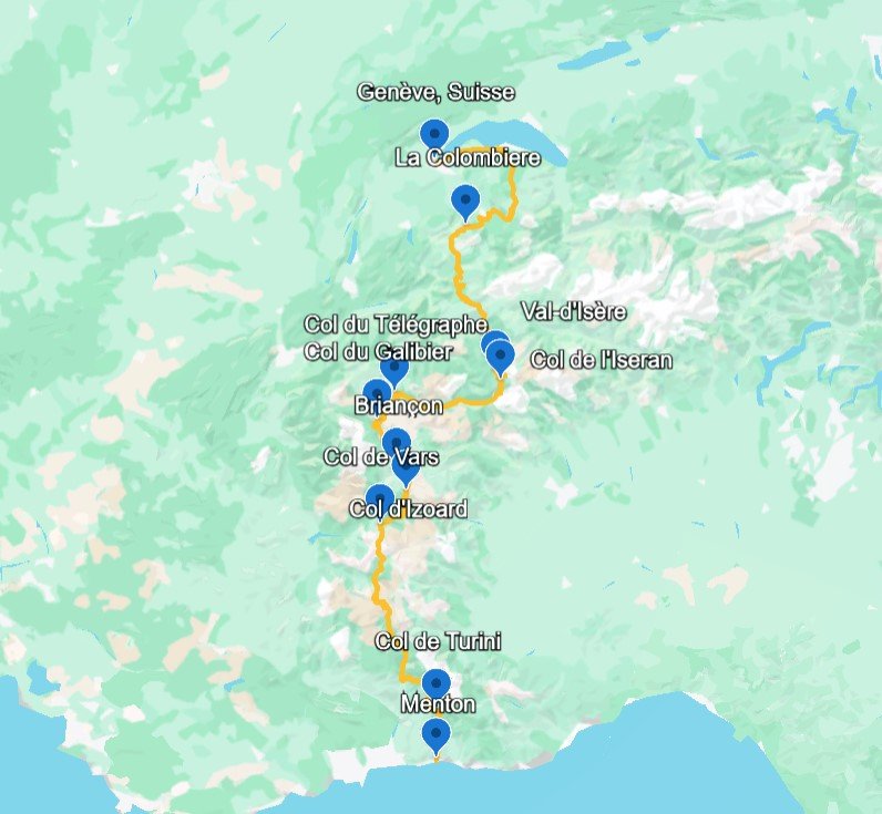
Route des Grandes Alpes Motorcycle Route
From Thonon-les-Bains on Lake Geneva to Menton on the Mediterranean, this north-to-south crossing links the most dramatic road passes of the French Alps in three demanding riding stages.
Start / finish and nearest airports
The Route des Grandes Alpes is one of Europe’s classic motorcycle crossings: a continuous thread of mountain engineering, glacier views, balcony roads and historic Tour de France climbs running from Lake Geneva to the Mediterranean. The official tourism route is usually presented at around 700–720 km, but a motorcycle version that deliberately includes the scenic high-pass variants and overnight detours should be treated as roughly 720–740 km before hotel access, fuel stops and local deviations. This version keeps the trip as a no-loop, north-to-south itinerary in three substantial stages: Thonon-les-Bains to Bourg-Saint-Maurice, Bourg-Saint-Maurice to Briançon, then Briançon to Menton. Expect long riding days, especially in summer traffic, with narrow hairpins, cold mornings above 2,000 m and rapidly changing weather. The reward is exceptional: Cormet de Roselend, Col de l’Iseran, Galibier, Izoard, Bonette and Turini compressed into a single alpine-to-sea adventure.
Interactive route map
Technical overview
Distances are calibrated against the official Route des Grandes Alpes range and remodulated into three motorcycle stages. Effective day mileage must be finalised in the GPX because hotel access, pass closures and chosen variants can alter the result.
Practical riding notes
Start early, keep fuel above half a tank in the high sections and never plan the Iseran, Galibier or Bonette in marginal weather. Late snow, road works, cycling events and afternoon storms can change the rhythm of the day. A mid-size or large adventure-tourer is ideal; heavy touring bikes are possible but require confidence on tight switchbacks and uneven alpine surfaces.
Seasonality & safety
The safest window is mid-June to late September. Some high passes can remain closed into June or close again after early autumn snow. Always check pass status locally before departure and keep a lower-altitude fallback route.
Roadbook
Stage 1 — Thonon-les-Bains to Bourg-Saint-Maurice · approx. 220 km / 137 miles
Effective km are only in the GPX available above; the stage distance shown here is indicative.
The opening stage leaves Lake Geneva and climbs immediately into Haute-Savoie, linking Morzine, Col des Gets, Col de la Colombière and Col des Aravis before the road turns deeper into Beaufortain country. The ride then becomes more cinematic around Lac de Roselend and the sweeping ascent of Cormet de Roselend. Bourg-Saint-Maurice is a practical overnight halt before the highest road of the next morning.
Base Camp Lodge
Modern alpine base with practical access for riders and on-site parking options.
Booking score: 8+Hotel Autantic
Quiet chalet-style stay outside the centre, useful for secure overnight parking.
Booking score: 8+Hotel Taj-I Mah
Higher-end alpine comfort in Arc 2000; suitable if you prefer a resort night above town.
Booking score: 8+Le Refuge Altitude 810
Mountain-style cuisine, Savoyard dishes and a relaxed end-of-stage atmosphere.
Macot-la-Plagne RAFTING: Descent of the Aime rapids
A 3-hour small-group whitewater descent on the Isère, with the activity base around 15 minutes from Bourg-Saint-Maurice by the N90.
Stage 2 — Bourg-Saint-Maurice to Briançon · approx. 255 km / 158 miles
Effective km are only in the GPX available above; the stage distance shown here is indicative.
This is the high-alpine centrepiece. The route climbs from Bourg-Saint-Maurice towards Val d’Isère and the immense Col de l’Iseran, the highest paved pass on the itinerary. Beyond Bonneval-sur-Arc, the road drops through the Maurienne before climbing again via Col du Télégraphe, Valloire and the legendary Col du Galibier. The descent by Col du Lautaret leads naturally to fortified Briançon.
Hôtel Mont-Brison
Central Briançon hotel, close to the Prorel lift and town services, with free on-site parking suitable for motorcycles.
Booking score: 8+Hôtel Vauban Briançon
Comfortable town option with easy access to restaurants and main roads.
Booking score: 8+SOWELL Hôtels Le Parc & Spa
More complete facilities, useful after a demanding high-pass day.
Booking score: 8+Le Gavroche
Well-known Briançon address with regional cooking and a historic-centre setting.
Serre Chevalier: Extreme Sport Rafting on the Guisane
A 2.5-hour guided whitewater activity in the Briançon valley, best suited to riders staying an extra night.
Stage 3 — Briançon to Menton · approx. 285 km / 177 miles
Effective km are only in the GPX available above; the stage distance shown here is indicative.
The final stage changes character several times. From Briançon it climbs through the lunar rock scenery of Col d’Izoard and the Queyras, then crosses Col de Vars to the Ubaye. South of Jausiers, the high road to Cime de la Bonette delivers the last great altitude drama before the route steps down through Mercantour country. The closing kilometres over Col de Turini and Sospel finally spill into Menton and the Mediterranean light.
Hôtel De Londres
Beach-side Menton hotel with private parking, a practical and comfortable finish after the alpine crossing.
Booking score: 8+Best Western Hôtel Méditerranée Menton
Central location, good access to the old town and seafront after arrival.
Booking score: 8+Princess et Richmond
Seafront comfort with a strong arrival-night feel after the alpine crossing.
Booking score: 8+Mirazur
World-famous Menton fine dining for a special finish; advance booking essential.
Menton Walking Tour: City Centre & Old Town
A 2.5-hour guided walk through Menton’s old town, monuments and lemon-growing heritage.
Best viewpoints near Menton
Useful search for coastal viewpoints and sunset stops.
POI Photo Gallery

Photo: chisloup, CC BY 3.0, via Wikimedia Commons.

Photo: Jean-Pierre Dalbéra, CC BY 2.0, via Wikimedia Commons.

Photo: Panoramio contributor, CC BY-SA 3.0, via Wikimedia Commons.

Photo: Marc Mongenet, licence as stated on file page, via Wikimedia Commons.

Photo: MartinD, licence as stated on file page, via Wikimedia Commons.

Photo: Wikimedia Commons contributor, CC BY-SA 4.0, via Wikimedia Commons.

Photo: patano, CC BY-SA 3.0, via Wikimedia Commons.

Photo: rene boulay, licence as stated on file page, via Wikimedia Commons.

Photo via Wikimedia Commons, licence as stated on file page.
Photo credits: images from Wikimedia Commons (see captions for authors and licenses). Used under CC BY-SA / public domain terms where applicable.