
Send download link to:
Alpine Crescent Loop
A five–stage alpine arc from Ljubljana to Innsbruck, designed for riders who prefer flowing rhythm, scenic asphalt and alpine passes over pure speed.
Nearest airport: Ljubljana Jože Pučnik (LJU) – ~30 min transfer by shuttle or taxi to city centre.
Nearest airport: Innsbruck (INN) – ~15–20 min by bus, tram or taxi to historic centre.
Mix of valley sweepers, technical passes and touristic towns. Suitable for confident riders.
Shoulder seasons for lower traffic on mountain passes; check snow closures in early/late season.
Route Overview
The Alpine Crescent Loop traces a gentle arc across the eastern Alps, linking Ljubljana, the lakes of Bled and Bohinj, the passes around Kranjska Gora, the legendary Vršič Pass and Grossglockner High Alpine Road, the lakeside villages of Hallstatt and Bad Ischl, the shoreline of Zell am See and the classic finale into Innsbruck.
Daily stages are built around a target of 180–240 km, with waypoints at roughly 30–40 km intervals. The design philosophy is rhythm over speed: you ride almost exclusively on asphalt, but the character constantly shifts between valley sweepers, forested side roads, balcony routes above deep valleys and big–view high passes. Each overnight stop is in a town with authentic accommodation, local food and activities that fit the riding mood, from evening walks along alpine lakes to spa sessions in historic resorts and cable car ascents to skyline viewpoints.
Starting in Ljubljana’s old town, you thread through medieval Škofja Loka and quiet Slovenian backroads to the lake triangle of Bohinj–Bled, then pivot north to Kranjska Gora, gateway to the Vršič and Wurzen passes. From there the route flows into Austria, taking a full day to explore the Grossglockner massif before curving east towards the Gastein valley, Bad Gastein, the UNESCO–listed landscape of Hallstatt and the imperial spa atmosphere of Bad Ischl.
The final stages cut back west via balcony roads into Zell am See, the valleys around Mittersill, and the scenic Gerlos Pass, before rolling into Innsbruck’s old town. From here, the loop can be closed by motorway or fast A–roads back towards Slovenia, or you can connect to onward trans–Alpine itineraries. Overall, it’s a rider–centric arc that balances distance, technical interest, sightseeing and recovery time, ideal for intermediate to experienced riders travelling on touring, sport–touring or adventure bikes with road–biased tyres.
Interactive Map – Alpine Crescent Loop
Legend: black = WP, red = POI/passes, blue = hotels, green = food, amber = fuel. Tap any marker to open Google Maps navigation.
Technical Overview
Practical riding notes
Expect changing grip and temperature around passes, with potential fog and wet patches in forested sections. Many stages cut through popular tourist areas (Bled, Hallstatt, Zell am See, Innsbruck), so allow extra time for traffic and photo stops. Fuel is generally available every 40–60 km along the route, but top up before committing to high–pass sections. Watch for cyclists and motorhomes on Grossglockner, and use engine braking to manage long descents.
Seasonability
Ideal months are June and September for a balance of open passes, manageable temperatures and moderate traffic. July and August bring the warmest weather but also the highest tourist density, especially around lakes and villages. In May and October, verify the status of high roads and be prepared for shorter daylight and possible overnight frost at altitude.
Stage 1 — Ljubljana → Bled → Kranjska Gora (~205 km) ▾
Flowing backroads from capital streets to lake country and mountain gateway.
Leave the cobbled streets of Ljubljana behind and slide into shaded backroads through Škofja Loka and the Selca valley, before turning towards Bohinjska Bistrica, Lake Bohinj and the iconic shores of Lake Bled. The day finishes with a relaxed run to Kranjska Gora, your base for the Vršič and Wurzen passes.
- Ljubljana → Škofja Loka — 34 km
- Škofja Loka → Železniki — 28 km
- Železniki → Bohinjska Bistrica — 31 km
- Bohinjska Bistrica → Bohinj Lake — 17 km
- Bohinj Lake → Bled — 26 km
- Bled → Kranjska Gora — 69 km
More options: restaurants in Kranjska Gora.
-
Hotel Kotnik (Boutique) – central, family–run, cosy alpine style.
9.2/10 Guest rating (approx., recent)
-
Ramada Resort / Hotel & Suites Kranjska Gora – larger resort opposite the slopes, spa & pools.
8.0/10 Guest rating (approx., recent)
- Vršič Pass sunset ride (self-guided; weather dependent).
- Walk at Lake Jasna (easy evening loop).
Road character: mostly flowing secondary roads with some narrow village sections; occasional rougher patches near Bohinj. Watch for cyclists and tourist buses near Bled.
Stage 2 — Kranjska Gora → Grossglockner → Heiligenblut (~230 km) ▾
Border crossing, high–valley cruising and a full Großglockner day.
From Kranjska Gora you cross into Italy at Tarvisio, then follow valley roads through Kötschach-Mauthen and Lienz, before committing to the iconic Grossglockner High Alpine Road and its high viewpoints above the Pasterze glacier, finishing in Heiligenblut.
- Kranjska Gora → Tarvisio — 24 km
- Tarvisio → Kötschach-Mauthen — 67 km
- Kötschach-Mauthen → Lienz — 36 km
- Lienz → Heiligenblut (via Großglockner) — 103 km
For dinner in town: search restaurants in Heiligenblut.
-
Nationalpark Lodge Grossglockner – alpine lodge style with spa and fireplace lounge.
8.6/10 Guest rating (approx., recent)
- Hotel Glocknerhof – traditional alpine hotel in Heiligenblut centre.
- Grossglockner High Alpine Road viewpoints (self-ride; toll road).
- Kaiser-Franz-Josefs-Höhe glacier viewpoints and short walks.
If you want, I can replace this with a different GYG activity near the stage corridor that has a true /tXXXXX/ deep link.
Road character: valley sections are easy and flowing; the Grossglockner section is steeper and more technical with hairpins, changing weather and heavy tourist traffic in peak season.
Stage 3 — Heiligenblut → Hallstatt → Bad Ischl (~210 km) ▾
From high–valley views to UNESCO lakes and imperial spa town.
Leaving Heiligenblut you flow north–east via Winklern and Oberdrauburg, cut across to Bad Gastein and then weave towards the mirror–flat waters of Hallstatt before finishing in the elegant streets of Bad Ischl.
- Heiligenblut → Winklern — 22 km
- Winklern → Oberdrauburg — 33 km
- Oberdrauburg → Bad Gastein — 61 km
- Bad Gastein → Hallstatt — 58 km
- Hallstatt → Bad Ischl — 36 km
More options: restaurants in Bad Ischl.
- Hotel Goldenes Schiff – central riverside hotel, easy walk to cafés and spa.
- Villa Seilern Vital Resort – wellness–focused villa resort with spa facilities.
- Hallstatt lakeside walk (best light: morning or late afternoon).
- Thermal / spa time in Bad Ischl.
Road character: relaxed, with busy tourist zones around Hallstatt; expect low speed limits and pedestrians on lakeside segments, but very rewarding scenery.
Stage 4 — Bad Ischl → Zell am See → Mittersill (~195 km) ▾
Salzkammergut exit, balcony roads and lakeside run into Zell am See.
This stage leads from the spa streets of Bad Ischl through Gosau, Abtenau and Bischofshofen, then along the valley towards Zell am See and finally to Mittersill, on the edge of the Hohe Tauern National Park.
- Bad Ischl → Gosau — 29 km
- Gosau → Abtenau — 41 km
- Abtenau → Bischofshofen — 46 km
- Bischofshofen → Zell am See — 52 km
- Zell am See → Mittersill — 27 km
More options: restaurants in Mittersill.
- Hotel Bräurup – historic brewery hotel in the centre of Mittersill.
- Sporthotel Kogler – sport & wellness hotel with pool and spa.
- Zell am See scenic stop + lakeside promenade ride.
- Hohe Tauern visitor centre / exhibition in Mittersill.
Road character: less intense than the big passes, ideal as a “breather” day with plenty of scenic photo stops and village cafés.
Stage 5 — Mittersill → Gerlos Pass → Innsbruck (~205 km) ▾
Classic alpine finale over Gerlos Pass into the Tyrolean capital.
The final riding day crosses Gerlos Pass towards Mayrhofen and Tux, runs north–west towards Seefeld and then drops into the valley floor for a finish in the old town of Innsbruck.
- Mittersill → Gerlos Pass — 39 km
- Gerlos Pass → Mayrhofen — 34 km
- Mayrhofen → Tux — 24 km
- Tux → Seefeld — 71 km
- Seefeld → Innsbruck — 37 km
Alternative: Die Wilderin for seasonal, local–produce cuisine.
- Hotel Innsbruck – spa hotel on the edge of the old town, easy walk to the Golden Roof.
- Stage 12 Hotel – design–oriented city hotel in the centre of Innsbruck.
- Nordkette cable car (Top of Innsbruck) – best skyline views.
- Old Town evening walk (Golden Roof area).
Road character: Gerlos Pass adds one last set of alpine curves; after Mayrhofen the riding gradually eases into more urban traffic as you approach Innsbruck.
Practical notes, safety & loop closure
Overall difficulty is moderate for an experienced road rider: no off–road, but repeated passes, variable weather and touristic traffic require focus and conservative pace on hairpins. Alpine weather can change quickly; always carry a mid–layer and waterproofs, and check pass conditions in the morning. Use engine braking to protect brakes on long descents and leave generous space to motorhomes and buses.
Fuel is easy to find in or near all overnight towns (Ljubljana, Kranjska Gora, Heiligenblut, Bad Ischl, Mittersill, Innsbruck). Nonetheless, refuel before entering Grossglockner and before Gerlos Pass so you can enjoy the riding without range anxiety. Mobile coverage is generally good, but some short stretches in deep valleys may be patchy.
The loop conceptually closes from Innsbruck back to Ljubljana using fast A–roads and motorway connections via Villach or Klagenfurt, depending on your time and weather window. This return leg can be covered in a single transit day, or extended with additional scenic detours if your schedule allows.
Photo gallery – key POIs


.jpg)


Images are loaded via Wikimedia Commons “Special:FilePath” for maximum WordPress compatibility. Licences and attributions are available on each linked file page.

Rent your motorcycle online with full insurance and easy pick-up near your starting point.
Find flights from your nearest airport
Detecting your nearest airport…
Related Posts :-
-
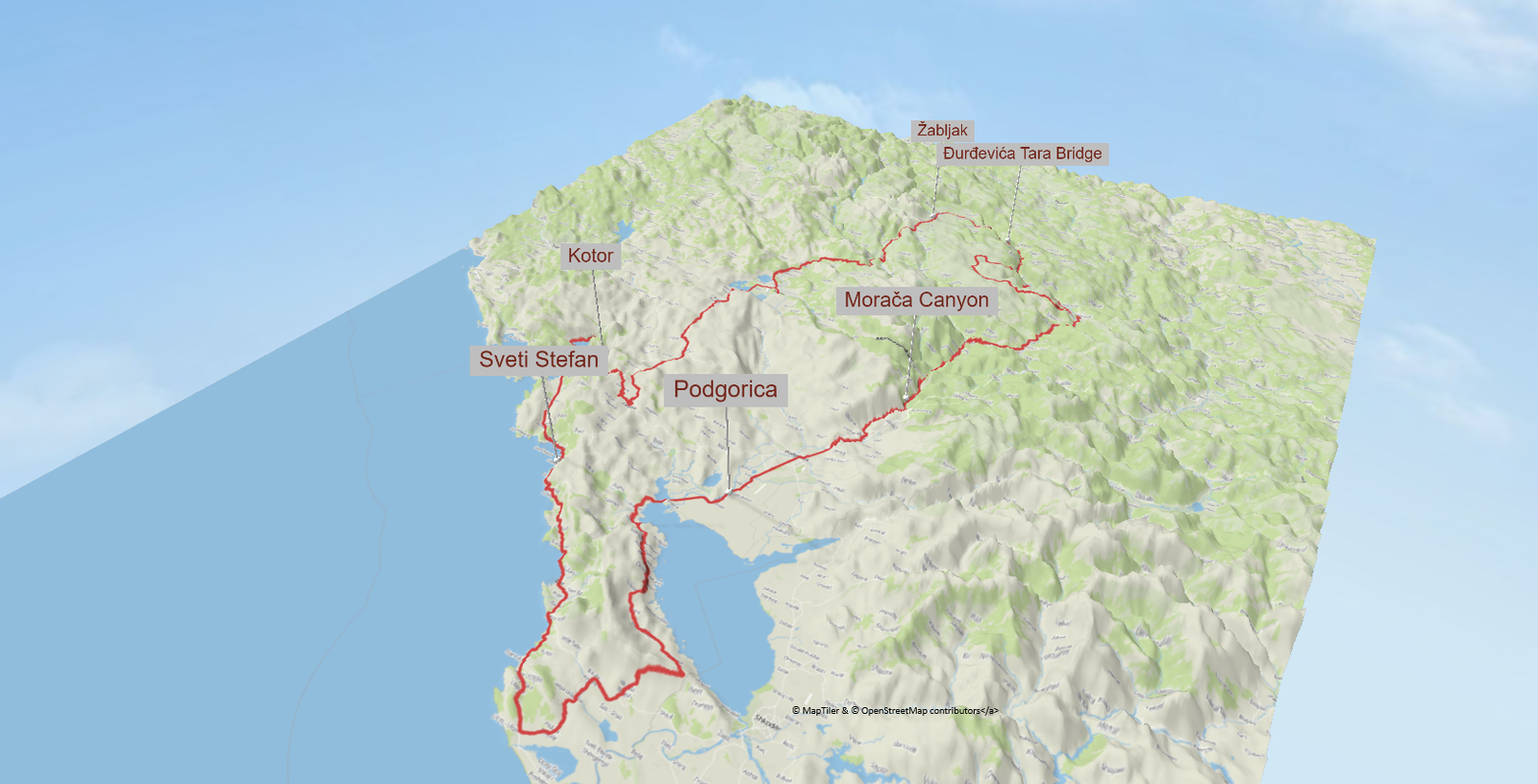
Europe Moto Loop Montenegro in 3 Epic Legs
A compact 3-leg motorcycle loop through Montenegro, from Moraca canyon…
-
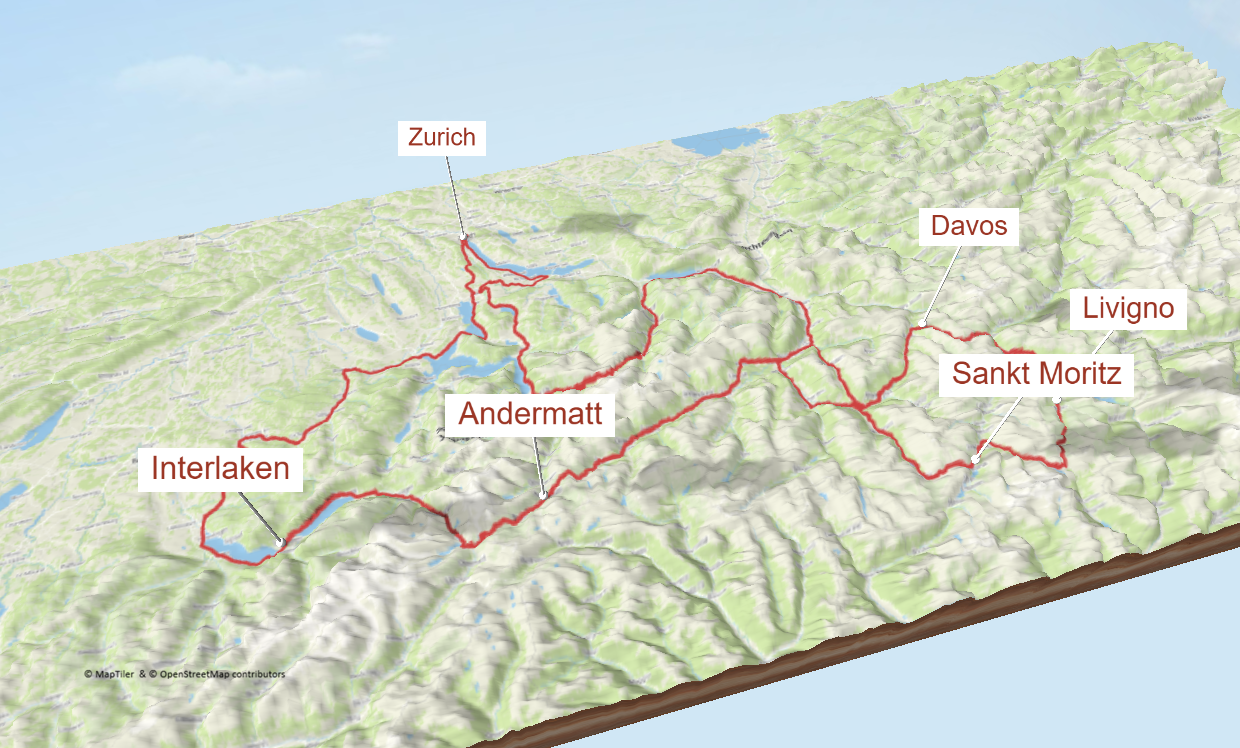
Europe – Switzerland – Zurich – 5 stages loop
A five-stage Swiss Alpine loop starting and ending in Zurich,…
-
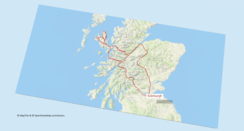
Scotland – 4 legs – Edinburgh
A 4-stage Edinburgh loop that packs in Scotland’s biggest riding…