Lykourgou 9, Kalamata. Current fleet includes a Honda Transalp 650 for touring/adventure use; airport, port and city-centre pickup options are published.
Journey overview
120 EMJ – Mani & Laconia Loop is a three-Stage circuit from Kalamata that joins three very different faces of the southern Peloponnese without using the same scenic road twice except where geography makes it unavoidable. The opening Stage is pure Mani: stone villages, a dry mountain spine, tiny harbours and the tower houses of Vathia before the route curls back up the eastern coast to Gytheio. Stage 2 changes pace, tracing the Laconian Gulf to Pounta and using the short ferry to Elafonisos for the road access to Simos Beach. It then returns to the mainland, crosses Neapoli and finishes beneath the rock of Monemvasia.
The final ride turns inland through Molaoi and Geraki to Sparta and Mystras, then saves one of the best riding sequences for last: the EO82 across the Taygetos through the Langada corridor and Artemisia. The complete accepted track is about 481 km / 299 mi. The route suits riders who enjoy narrow secondary roads and are happy to trade average speed for scenery. September is particularly attractive, but the Elafonisos ferry is weather-dependent and the Taygetos crossing deserves a live conditions check in shoulder seasons. The Stage 2 distance is intentionally shorter because ferry queues, the island visit and the Monemvasia arrival experience consume real time.
481 km / 299 miModerate–challengingBest: spring / early autumn
Before you ride
Best season
April–June and September–October are the natural windows. Summer heat can be severe; winter conditions can affect the Taygetos.
Elafonisos ferry
Published September timetable: frequent 8–10 minute crossings. The operator currently posts a weather-related suspension notice, so confirm live before Stage 2.
Nearest airport
Kalamata International Airport is the practical air gateway for both start and finish.
Rider kit
Ventilated protective kit, sun protection, water, light rain layer, tyre repair / inflation kit and a compact overnight bag for Monemvasia’s pedestrian castle.
Motorcycle rental in Kalamata
Faron 139, Kalamata. Published fleet includes Transalp 650/700, Deauville 650 and KLE 500; exact availability must be confirmed directly.
Route fit: prefer a road/touring or mid-size adventure motorcycle rather than a small urban scooter for Deep Mani and the Taygetos crossing. Fleet, price, insurance, deposit, mileage and availability are dynamic.
Stage 1 · Kalamata → Gytheio
189 km / 117 mi≈4 h movingModerate · technical in Deep Mani
The first Stage wastes no time finding the Mani. From Kalamata the route slips south along the Messenian Gulf, then tightens through the stone villages and dry slopes that make this peninsula one of southern Greece’s most distinctive riding areas. Kardamyli and Limeni provide the softer, postcard side of the coast; after Areopoli, the road becomes narrower, more exposed and more rhythmically demanding.
Deep Mani is the heart of the day. Gerolimenas, Alika and Vathia arrive in quick succession, with tower houses, limestone and sea appearing at almost every bend. The accepted route continues to Marmari and Porto Kagio before turning north on the eastern side via Lagia, Kokkala, Kotronas and Skoutari. It is not a fast 189 km: blind bends, village entries and frequent photo stops make a relaxed timetable essential. Gytheio is a natural finish — a harbour town where the motorcycle can be left for a compact waterfront walk to Kranai.
Kalamata → Kardamyli → Oitylo → Limeni → Areopoli → Pyrgos Dirou → Mezapos → Gerolimenas → Vathia → Porto Kagio → Kokkala → Kotronas → Skoutari → Gytheio.
Elevation
Elevation is data-driven in the Route App from the accepted GPX geometry. Use the interactive Route App for the live All / Stage profile if this printable is opened offline.
Rider Intelligence
EMJ Rider Intelligence
Checked 7 Sep 2026Stage 1 riding brief
Planning guidance for this specific Stage. Dynamic conditions must be rechecked before departure.
1 · Riding Timeline
Moving time: ≈4 hStart: 08:30–09:00
Leave enough margin for photography, a proper lunch and the arrival walk. These are EMJ planning estimates rather than guaranteed journey times.
2 · Rider Effort Profile
Effort: 4/5Pillion: Suitable for an experienced pillion; repeated tight bends
Expect repeated bends, village approaches and sections where road width and sight lines matter more than outright speed.
3 · Fuel Plan
Start full at Shell Artemidos in Kalamata. Use the Mavrovouni / Gytheio approach station as the practical backup.
Card acceptance, product availability and opening hours can change. The map layer contains only the selected primary / backup stops.
4 · Critical Sections
Deep Mani from Gerolimenas through Vathia and Porto Kagio: narrow carriageway, stone walls, blind bends and occasional rough edges demand margin.
5 · Bad-weather / Closure Plan
If wind or rain makes Deep Mani uncomfortable, turn back before the southern tip and use a more direct main-road corridor towards Gytheio rather than forcing the exposed coast.
Any fallback described here is an emergency planning corridor, not a separately validated navigation route.
6 · Last Conditions Check
No route-specific road closure is asserted from a negative search. Recheck official traffic and weather information 24–48 hours before riding.
POIs
- Kardamyli — Stone lanes, sea views and a compact old quarter at the gateway to the Mani.
- Limeni — Tiny stone harbour set directly beneath the bare Mani slopes.
- Areopoli — Traditional stone town and a natural coffee stop before entering Deep Mani.
- Diros Caves — Famous cave system near Pyrgos Dirou; allow extra time if visiting rather than only stopping outside.
- Gerolimenas — Sheltered harbour framed by limestone cliffs and old waterfront buildings.
- Vathia — Signature tower-house settlement of the southern Mani, dramatic against the dry ridge.
- Porto Kagio — Small anchorage near the southern tip of mainland Greece.
- Skoutari — Quiet bay and village on the eastern side of Mani before the run to Gytheio.
Hotels
 LAS HOTEL & SPA
Central Gytheio base close to the waterfront and evening walk.
Review summary: A polished central option repeatedly praised for location, modern rooms and rooftop facilities; useful when you want to park once and walk into town.
 Pantheon City Hotel
Waterfront hotel in the heart of Gytheio.
Review summary: A practical town-centre choice with harbour views and immediate access to the promenade, restaurants and the compact historic core.
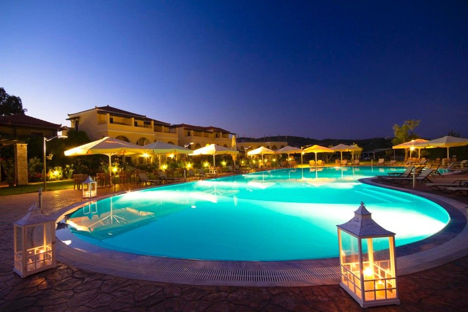 Aktaion Resort
Resort-style stay north of Gytheio at Selinitsa.
Review summary: Quieter than the harbour hotels, with more resort space and a strong guest score. Confirm motorcycle parking arrangements directly before arrival.
Restaurants
Greek / Mediterranean · local produce
Review summary: A Rachi estate restaurant built around local agricultural and livestock products, Mani herbs, local wine and tsipouro.
Greek
Review summary: Central Gytheio choice near the harbour and Town Hall area, easy to reach on foot from the core hotel cluster.
Coffee · crêpe · pizza
Review summary: A casual central fallback for a lighter or later meal rather than a formal dinner.
Local flavours
Mani olive oil and dishes scented with local herbs are the natural theme here. Look for lalangia, crisp fried dough associated with the Peloponnese, and simple grilled fish in Gytheio.
Arrival walking tour
Verified locality sequenceArrival walk
Approx. 1–3 km depending on the chosen hotel and optional detours.Re-order from your hotel in Google Maps if needed.
1
Gytheio Town Hall Square
Harbour-side civic square and a useful orientation point.
Continue on footKeep the visible stop order
2
Tzanetakis Tower
Historic Mani tower on Kranai island.
Continue on footKeep the visible stop order
3
Gythio Lighthouse
1873 lighthouse at the eastern end of Kranai.
Stage 2 · Gytheio → Monemvasia
137 km / 85 mi≈3 h moving + ferry / island timeModerate · ferry logistics
Stage 2 is deliberately shorter on the odometer because the day is built around Elafonisos rather than continuous saddle time. From Gytheio the route follows the Laconian Gulf through Skala, Vlachiotis and the quieter coastal sequence around Plytra and Archangelos before reaching the Pounta ferry access. The short crossing is part of the experience, but it is also the day’s main operational variable.
On Elafonisos the accepted route goes to the road access for Simos Beach, keeping the motorcycle on the legal approach rather than placing a waypoint on the sand. After returning on the same island access road — an unavoidable repetition — the ferry brings the route back to Pounta. Neapoli gives a practical fuel and coffee reset before the final northbound run to Monemvasia. The riding itself is easier than Stage 1, yet the ferry can consume significant time when wind disrupts sailings. The reward is an early enough arrival to park on the Gefyra side and enter the medieval castle town on foot.
Gytheio → Skala → Vlachiotis → Plytra → Archangelos → Pounta → Elafonisos → Simos Beach → Pounta → Neapoli → Monemvasia.
Elevation
Elevation is data-driven in the Route App from the accepted GPX geometry. Use the interactive Route App for the live All / Stage profile if this printable is opened offline.
Rider Intelligence
EMJ Rider Intelligence
Checked 7 Sep 2026Stage 2 riding brief
Planning guidance for this specific Stage. Dynamic conditions must be rechecked before departure.
1 · Riding Timeline
Moving time: ≈3 h + crossingsStart: 08:30–09:00
Leave enough margin for photography, a proper lunch and the arrival walk. These are EMJ planning estimates rather than guaranteed journey times.
2 · Rider Effort Profile
Effort: 3/5Pillion: Good, but ferry loading and walking luggage add effort
Expect repeated bends, village approaches and sections where road width and sight lines matter more than outright speed.
3 · Fuel Plan
Refuel in Neapoli after returning from Elafonisos. The Monemvasia-area BP is the backup before the overnight.
Card acceptance, product availability and opening hours can change. The map layer contains only the selected primary / backup stops.
4 · Critical Sections
Pounta ↔ Elafonisos ferry is weather-sensitive. Simos requires an out-and-back island access road; allow time for loading queues and beach traffic.
5 · Bad-weather / Closure Plan
If ferries are suspended, omit Elafonisos and continue from Pounta / Viglafia to Neapoli and Monemvasia on the mainland.
Any fallback described here is an emergency planning corridor, not a separately validated navigation route.
6 · Last Conditions Check
Ferry alert: the published September timetable is active, but the operator page checked on 7 Sep 2026 currently reports that the next departure is cancelled because of adverse weather. Do not ride to Pounta assuming the sailing will operate.
No route-specific road closure is asserted from a negative search. Recheck official traffic and weather information 24–48 hours before riding.
POIs
- Plytra — Low-key Laconian Gulf waterfront and a relaxed coastal break.
- Archangelos — Compact fishing village reached on a quieter coastal spur.
- Pavlopetri — Submerged Bronze Age settlement off Pounta; best appreciated from the shore unless sea conditions are suitable.
- Elafonisos — Short ferry crossing to an island of turquoise shallows and low sandy landscapes.
- Simos Beach — Twin-bay beach reached by the island road; the route waypoint is at the road access, not on the sand.
- Neapoli Voion — Working harbour town and practical mainland pause after returning from Elafonisos.
- Monemvasia Castle — Medieval fortified town on its rock, reached on foot from the causeway / Gefyra side.
Hotels
 Likinia Hotel
Atmospheric stay inside the castle town.
Review summary: Highly rated for setting, character and views inside the pedestrian castle. Leave the motorcycle on the Gefyra / causeway side and walk in with luggage.
 Malvasia Traditional Hotel
Traditional rooms woven into Monemvasia’s lower town.
Review summary: A long-established castle option with strong review volume and direct access to the lanes and waterfront terraces; expect pedestrian luggage transfer.
 Bastione Malvasia Hotel
Character hotel at the eastern side of the castle settlement.
Review summary: Strong guest feedback for atmosphere and sea views. As with all in-castle choices, plan parking outside the walls and carry only overnight essentials.
Restaurants
Greek / wine bar restaurant
Review summary: Set in the lower castle town close to Elkomenos Christos Square; useful for a relaxed evening without leaving the walls.
Greek
Review summary: Traditional Greek cooking in the lower town, close to the central square and main visitor flow.
Greek / Mediterranean
Review summary: A mainland Gefyra alternative that is especially convenient if your hotel and motorcycle stay outside the castle.
Local flavours
Monemvasia is closely associated with the historic sweet wine tradition behind Malvasia. Pair local wine with seafood, olives and regional cheeses after the castle walk.
Arrival walking tour
Verified locality sequenceArrival walk
Castle lanes are pedestrian, stepped and uneven; the upper town is not included in this compact lower-town circuit.Re-order from your hotel in Google Maps if needed.
1
Central Gate
Pedestrian entrance to the fortified town.
Continue on footKeep the visible stop order
2
Church of Christ Elkomenos
Principal church on the lower-town square.
Continue on footKeep the visible stop order
3
Archaeological Collection of Monemvasia
Collection housed in the former mosque opposite Elkomenos Christos.
Continue on footKeep the visible stop order
4
Panagia Chrysafitissa
Atmospheric square and church towards the eastern side of lower town.
Stage 3 · Monemvasia → Kalamata
155 km / 96 mi≈3 h movingModerate–challenging · mountain finish
The final Stage leaves the coast behind and crosses the interior of Laconia. Sykia and Molaoi lead towards Geraki, where the landscape is broader and less tourist-focused than the Mani coast. Sparta is the strategic pause: from here the route turns towards Mystras and the Taygetos rather than taking the faster lowland alternatives.
Mystras is worth a proper stop if time and riding kit allow, but the motorcycle highlight comes immediately afterwards. The EO82 through Tripi and the Langada corridor threads across the Taygetos with steep rock walls, changing sight lines and a succession of bends. The accepted track then reaches Artemisia and descends into Messenia, finishing back in Kalamata. This section is particularly sensitive to rain, low cloud, debris and winter conditions, so the mountain should never be treated as guaranteed simply because there is no current closure notice. In good weather it is a fitting final chapter: historic Laconia behind you, the Messenian Gulf reopening ahead and Kalamata waiting for a final dinner.
Monemvasia → Sykia → Molaoi → Geraki → Sparta → Mystras → Tripi → Langada / Taygetos → Artemisia → Kalamata.
Elevation
Elevation is data-driven in the Route App from the accepted GPX geometry. Use the interactive Route App for the live All / Stage profile if this printable is opened offline.
Rider Intelligence
EMJ Rider Intelligence
Checked 7 Sep 2026Stage 3 riding brief
Planning guidance for this specific Stage. Dynamic conditions must be rechecked before departure.
1 · Riding Timeline
Moving time: ≈3 hStart: 08:30–09:00
Leave enough margin for photography, a proper lunch and the arrival walk. These are EMJ planning estimates rather than guaranteed journey times.
2 · Rider Effort Profile
Effort: 4/5Pillion: Reasonable for an experienced pillion in good weather
Expect repeated bends, village approaches and sections where road width and sight lines matter more than outright speed.
3 · Fuel Plan
Use BP in Sparta as the primary mountain-crossing refill. Shell Artemidos in Kalamata is the backup / finish option.
Card acceptance, product availability and opening hours can change. The map layer contains only the selected primary / backup stops.
4 · Critical Sections
EO82 / Taygetos after Mystras: mountain bends, rock-cut sections, rapidly changing visibility and limited easy overtaking.
5 · Bad-weather / Closure Plan
If Taygetos conditions deteriorate, do not commit to the high crossing; turn back towards Sparta and select a lower, longer main-road alternative using current navigation and official conditions.
Any fallback described here is an emergency planning corridor, not a separately validated navigation route.
6 · Last Conditions Check
No route-specific road closure is asserted from a negative search. Recheck official traffic and weather information 24–48 hours before riding.
POIs
- Geraki Castle — Ruined medieval stronghold above Geraki, overlooking inland Laconia.
- Sparta — Modern city laid over ancient Lacedaemon; useful pause before the Taygetos crossing.
- Mystras — UNESCO-listed Byzantine city on the lower Taygetos slopes.
- Tripi — Village marking the eastern approach to the EO82 Taygetos crossing.
- Langada Pass / EO82 — Narrow, twisting mountain corridor through the Taygetos — the technical highlight of Stage 3.
- Artemisia — Mountain village on the western descent towards Messenia.
- Kalamata Old Town — Historic centre around 23 March Square, Holy Apostles and the cathedral district.
Hotels
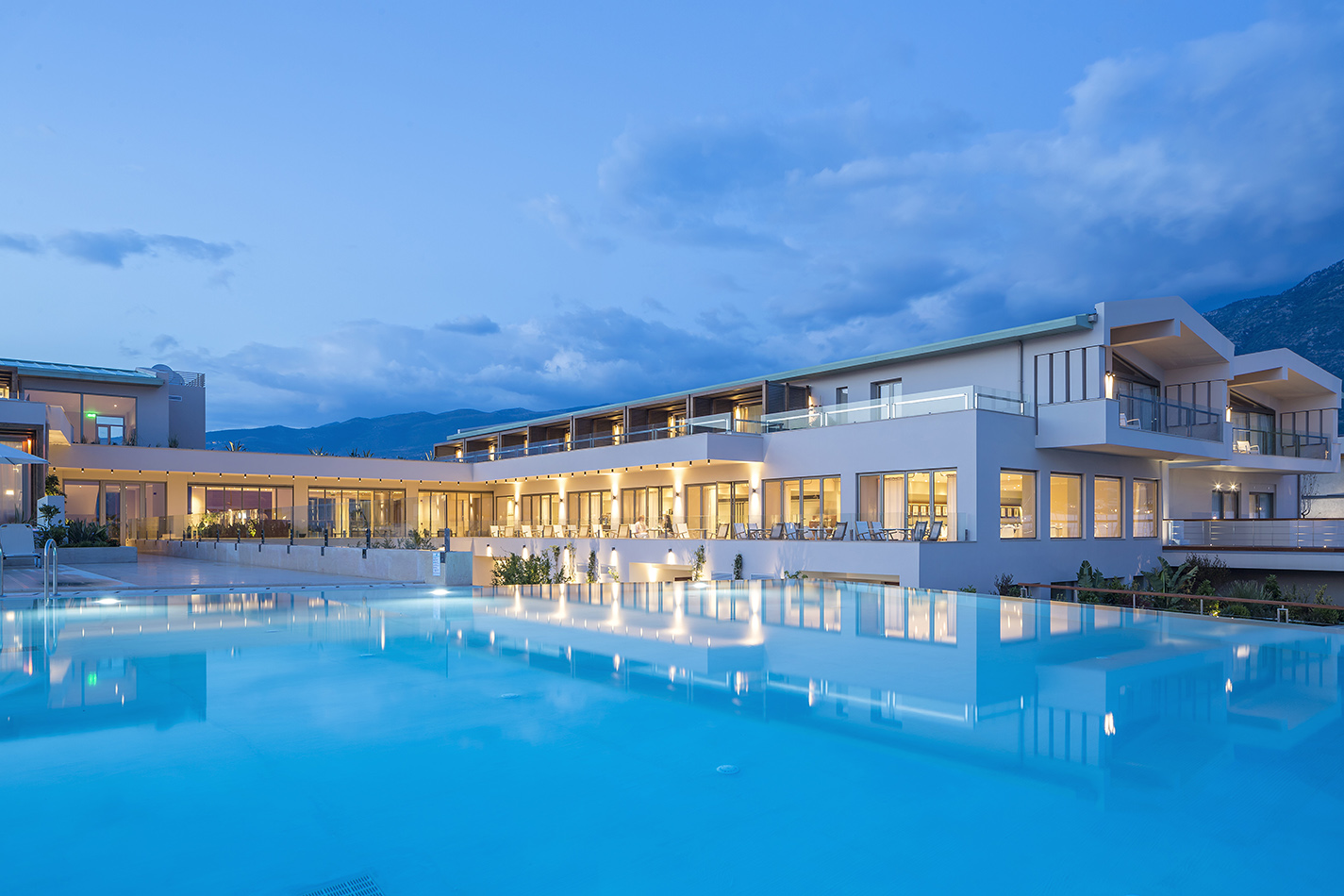 Horizon Blu Boutique Hotel
Beachfront finish-night option west of central Kalamata.
Review summary: A comfortable end-of-loop choice if you prefer the seafront and a resort-style finish rather than the historic centre.
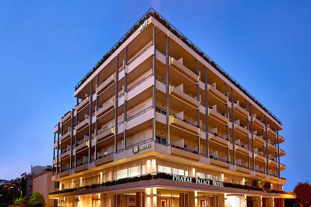 Pharae Palace
Seafront hotel on Kalamata’s urban beach corridor.
Review summary: Well placed between the marina/seafront and city centre, making it easy to finish the ride and still walk out for dinner.
 Grand Hotel Kalamata
Central harbour-side boutique option.
Review summary: A higher-end urban finish with strong guest feedback and convenient access to the port district. Confirm secure motorcycle parking directly.
Restaurants
Greek home cooking
Review summary: Highly rated, unpretentious Greek cooking in the historic centre, ideal after a technical mountain finish.
Modern Greek
Review summary: A popular city-centre restaurant combining Greek ingredients with a more contemporary presentation.
Mediterranean / seafood
Review summary: Marina-side option suited to a final evening by the water.
Local flavours
Kalamata’s name is inseparable from the Kalamata olive. The Messenian table also leans on extra-virgin olive oil, figs, mountain herbs and seafood from the gulf.
Arrival walking tour
Verified locality sequenceArrival walk
Approx. 1–3 km depending on the chosen hotel and optional detours.Re-order from your hotel in Google Maps if needed.
1
23 March Square
Historic square associated with the city’s liberation.
Continue on footKeep the visible stop order
2
Church of the Holy Apostles
Key landmark on 23 March Square.
Continue on footKeep the visible stop order
3
Archaeological Museum of Messenia
Regional archaeological collection in the old market area.
Continue on footKeep the visible stop order
4
Ypapanti Cathedral
Metropolitan cathedral and focal point of the Old Town.
Seasonality & weather
These shoulder-season months best balance daylight, coastal temperatures and touring comfort. July–August can be very hot on exposed Mani and Laconian roads; winter weather can make Taygetos colder and less predictable.
Deep Mani and Elafonisos are exposed to sun, heat and wind; Taygetos can be markedly cooler, cloudier or wetter. Carry water and sun protection plus a light insulating and waterproof layer.
Check sector-specific weather, roadworks, temporary restrictions and the current Elafonisos ferry notice before riding. The roadbook is not a live-conditions service.
Rider clothing & kit
Use ventilated protective kit for the coast and carry a compact warm layer for early starts, wind and Taygetos.
Keep a light waterproof layer accessible and carry enough water plus sun protection for exposed and quieter Mani sectors.
Clear visor, offline navigation, charged phone/power supply and a tyre repair/inflation kit are sensible. Compact luggage helps in pedestrian Monemvasia.
Practical recommendations
Expect pace to vary between flowing coast roads and narrow Deep Mani lanes. Ride for visibility and surface condition rather than average speed.
Use the selected Primary/Backup fuel stops. On Stage 2 allow margin for Pounta–Elafonisos ferry queues, weather disruption, beach time and the return crossing.
Download the GPX + ITN and offline mapping before departure. Recheck temporary works, ferry status and Taygetos conditions before each Stage.
Food, wine & distinctive producers
Traditional grape-pomace spirit served with meze across the Peloponnese.
Honey-based local drink associated with Monemvasia specialist producers and delicatessens.
PDO Monemvasia-Malvasia
The historic Monemvasia sweet-wine identity is now a protected designation. Look for wines based on local Monemvasia and other permitted Laconian grapes.
Laconian wine guide ↗PGI Laconia · Kydonitsa
A distinctive local white grape. Estate Theodorakakos produces organic Kydonitsa and explicitly welcomes winery/vineyard visits and tastings.
Estate & tasting ↗Mavroudi
A local red variety closely associated with Laconia, made varietally and in blends; a natural match for smoked pork and mature cheeses.
Laconian wines ↗Mani extra-virgin olive oil
Koroneiki dominates the landscape. Rachi of Mani and Passavas Estate connect the ride directly to family groves around Gytheio.
Rachi of Mani ↗Syglino & orange sausage
Smoked Mani pork and orange-scented sausage are two of Laconia’s most characteristic savoury products.
Regional cuisine ↗Sfela PDO cheese
A firm, salty sheep-and-goat cheese of the southern Peloponnese, ideal beside olives, bread and local wine.
Local products ↗Honey, herbs & lupins
Thyme honey, sage, mountain herbs and lupin beans belong to the older Mani pantry and make good market finds during the ride.
Mani products ↗Monemvasia delicatessen
Edodimopolio carries local olive oil, wines, almond sweets, liqueurs, preserves, herbs and melitokraso / hydromeli inside the castle.
Local products ↗Visitor-facing winery: Estate Theodorakakos explicitly welcomes vineyard/winery visits and tastings; it is a deliberate Stage 3 deviation and should be contacted ahead. Stage 2: Asopos Groves publishes its exact location and contact hours. Stage 1: Rachi/Gytheio is documented olive country; contact estates before assuming visitor access.
Route gallery


Fuel & Services
Checked primary and backup fuel options used by Rider Intelligence.
≈ 1 km from route start · G1
Artemidos 202, Kalamata
0.96 km from nearest sampled route point
Primary / start
Official Shell listing: 06:00–22:00 daily
Checked 7 Sep 2026
≈ 185 km from route start · G1
Mavrovouni, East Mani
0.1 km from nearest sampled route point
Backup
Opening hours and fuel availability are dynamic — check live before relying on it
Checked 7 Sep 2026
≈ 297 km from route start · G2
Neapoli Voion, Laconia
0.04 km from nearest sampled route point
Primary
Opening hours and fuel availability are dynamic — check live before relying on it
Checked 7 Sep 2026
≈ 332 km from route start · G2
North of Monemvasia / Agia Paraskevi corridor
0.26 km from nearest sampled route point
Backup
Opening hours and fuel availability are dynamic — check live before relying on it
Checked 7 Sep 2026
≈ 419 km from route start · G3
Southern Sparta urban corridor
1.5 km from nearest sampled route point
Primary
Opening hours and fuel availability are dynamic — check live before relying on it
Checked 7 Sep 2026