
Flamboyant Gothic masterpiece commissioned by Margaret of Austria; an exceptional cultural start before leaving Bourg-en-Bresse.
Interactive route map
Complete route map
Map layers are independent and cumulative. Numbered route anchors can be hidden without removing the route line or curated POIs.
Stage 1Stage 2● ★ POINumbered WaypointH HotelR Restaurant
The map uses the Route #114 GPX track directly and remains available in All, Stage 1 and Stage 2 views.
Elevation profile
Complete loop elevation profile
Distance on the horizontal axis and terrain elevation on the vertical axis. Move the pointer or a finger across the profile to inspect kilometre and elevation.
Loading terrain elevation…
Minimum elevation—
Maximum elevation—
Total ascent—
Total descent—
Elevation source: live terrain values use the Open-Meteo Elevation API / Copernicus DEM GLO-90. A built-in route-anchor profile is rendered immediately as a resilient fallback if the live endpoint is unavailable; fallback statistics are marked with ≈.
The journey
Two days from the Bresse plain to the high Jura
This compact two-day loop begins and ends in Bourg-en-Bresse, using the lower Jura as a gateway to progressively higher, more technical roads. Stage 1 leaves the Bresse plain on the D936 and climbs through the Revermont towards Thoirette-Coisia and Dortan. The route then folds north through Moirans-en-Montagne and Saint-Claude, where the scenery changes from open foothills to tighter limestone valleys and forested highlands.
The second half of the first day runs through the Jura lake country around Bonlieu and La Chaux-du-Dombief, before the N5 rises via Morbier and Morez to the overnight in Les Rousses. At only 149 km (92 mi), the distance is deliberately modest: this is a day for viewpoints, short walks and food stops rather than chasing an average speed.
Stage 2 adds a different rhythm. The road crosses briefly into Switzerland over Col de la Givrine, drops through Saint-Cergue and Gingins, then returns to France for the climb from Gex to Col de la Faucille. From Mijoux the loop descends towards Saint-Claude, turns through Oyonnax and protects the more involving line over Col du Berthiand before closing through Poncin and Pont-d'Ain. The complete loop measures 323 km (200 mi): short enough for two relaxed days, but varied enough to feel like a complete Jura journey.
Cross-border note: Stage 2 briefly enters Switzerland. Carry the normal travel documents for the countries you ride through and recheck current border, road and weather information before departure.
Highlights along the route
Why this loop works
The route is short enough to stop often, but the scenery and riding character change repeatedly. These are the most useful route-wide highlights; the Stage views contain the complete curated POI sets.
The monumental heart of Saint-Claude and a useful pause before the route turns north into the lake country.
A quiet glacial lake framed by forest; ideal for a short scenic pause close to the route.
Jura’s celebrated waterfall system. A worthwhile optional stop if you have time for a walk away from the motorcycle.
Morez’s optical heritage museum, directly relevant to the industrial history of the high Jura.
A vast nineteenth-century fort now used for Comté maturation; guided visits make an excellent end-of-stage activity.
The first cross-border high point of the day, carrying the road from the French Jura into Vaud.
The signature climb of Stage 2, with a succession of bends and, in clear weather, views towards Lake Geneva and Mont Blanc.
The protected road anchor that keeps the return on the more rewarding D85 rather than a faster lowland shortcut.
Technical and practical
Plan for mountain weather, not motorway pace
Route rhythm
Frequent villages, changing gradients and tighter mountain sections keep average speed modest. The low daily distances are intentional and leave time for stops.
Weather
Conditions around Les Rousses and Col de la Faucille can be cooler, wetter and windier than the Bresse plain. Recheck the forecast on both mornings.
Season
May to October is the practical touring window. Outside it, cold, snow or temporary restrictions can affect the higher Jura sections.
Nearest airport
Fly & ride
Motorcycle rental near Bourg-en-Bresse
Two credible motorcycle-rental programmes are available within the immediate Bourg-en-Bresse area. Availability, exact model, price, deposit, mileage allowance and rental conditions can change, so confirm the motorcycle and terms directly before travelling.
Bresse Motor Bike — Yamaha Rent
Yamaha Rent lists this Bourg-en-Bresse/Péronnas agency with a current rental fleet that includes the Ténéré 700 alongside MT and scooter models. For this paved Jura loop, the Ténéré 700 is the most obvious route-suitable option in the published fleet; confirm the exact bike for your dates before booking.
Bresse Moto Sport — BMW Rent A Ride
Bresse Moto Sport in Viriat is listed by BMW Rent A Ride as an official rental partner. BMW's programme supports short rentals and road trips; the exact motorcycles shown for a chosen date can vary, so select and confirm a touring, roadster or GS-type model appropriate for the route when booking.
EMJ planning note: A mid-size adventure, sport-touring or roadster motorcycle is well suited to Route #114. Rental fleets and conditions are dynamic; recheck licence requirements, cross-border permission for the short Swiss section, insurance, deposit and mileage terms with the rental company before departure.
Food & wine
A taste map of the complete Jura loop
The route moves through two distinct food landscapes. In the Haut-Jura, the strongest anchors are Comté AOP, Morbier and Bleu de Gex, while the return towards Bourg-en-Bresse brings the route back into the territory of Poulet de Bresse. Jura wine culture is unusually diverse for such a compact region: classic dry whites and reds sit beside oxidative, sparkling and fortified styles. The motorcycle route itself is not a wine-tasting itinerary, so any tasting belongs after the bike is parked. On Stage 2 the line through Poncin also reaches the Bugey wine area, where pink, lightly sparkling Cerdon gives the final kilometres a different local identity.
Vin JauneOxidative Jura speciality traditionally associated with Savagnin.
Vin de PailleSweet wine made from grapes dried before pressing.
Macvin du JuraTraditional Jura fortified mistelle served as an aperitif or with dessert.
Crémant du JuraTraditional-method sparkling wine produced across the Jura appellation area.
Marc du JuraRegional grape-marc spirit with a long local tradition.
Bugey CerdonLightly sparkling rosé associated with the Ain and the Poncin/Cerdon area.
Rider planning
Useful kit for this two-day mountain loop
Layer for altitude
Les Rousses and the higher passes can be markedly cooler than Bourg-en-Bresse. Pack a light insulating layer even in summer.
Waterproof outer layer
Fast-changing Jura weather makes a compact waterproof jacket or laminated shell more useful than relying on a warm lowland forecast.
Offline navigation
Carry the GPX + ITN files locally and keep a charged phone or GPS. Forested valleys and border sections are poor places to depend on a single live connection.
9 verified images
Jura landscapes and route anchors
Click or press Enter on an image to enlarge; use arrows or swipe to continue.


Stage 1
Bourg-en-Bresse → Les Rousses
Distance149 km / 92 mi
Riding time3½–4 hr
DifficultyModerate
Leave Bourg-en-Bresse and let the road settle quickly into the foothills. The D936 is the key opening thread: broad enough to flow, yet constantly shaped by villages, shallow crests and the first limestone ridges of the Revermont. Beyond Thoirette-Coisia and Dortan, the terrain closes in and the ride becomes more distinctly Jura, with river valleys and wooded slopes limiting sight lines and keeping speeds naturally moderate.
Moirans-en-Montagne is the gateway to the lake country, while Saint-Claude provides the cultural pivot of the stage. North of town the route climbs into cooler forest and a succession of smaller roads around Bonlieu and La Chaux-du-Dombief. This is where stopping pays off: glacial lakes, the nearby Cascades du Hérisson and elevated viewpoints can easily turn a short riding day into a full day out.
The final section through Morbier and Morez rises to Les Rousses. The high-Jura air, cheese culture and compact village make it a natural overnight. Allow extra margin in rain or mist: shaded roads can stay damp, and the best pace here is smooth rather than hurried.
Route sequence
Bourg-en-Bresse → Thoirette-Coisia → Dortan → Moirans-en-Montagne → Saint-Claude → Bonlieu → La Chaux-du-Dombief → Saint-Laurent-en-Grandvaux → Morbier → Morez → Les Rousses
POIs on this stage
Flamboyant Gothic masterpiece commissioned by Margaret of Austria; an exceptional cultural start before leaving Bourg-en-Bresse.
The opening ribbon into the first Jura foothills: rolling gradients, villages and a steady sequence of bends.
Reservoir scenery near the Ain–Jura transition, close to the route between Dortan and Moirans-en-Montagne.
A strong local-industry stop in Moirans-en-Montagne, the historic French toy-making centre.
The monumental heart of Saint-Claude and a useful pause before the route turns north into the lake country.
Compact museum explaining the two crafts most closely associated with Saint-Claude.
A quiet glacial lake framed by forest; ideal for a short scenic pause close to the route.
Jura’s celebrated waterfall system. A worthwhile optional stop if you have time for a walk away from the motorcycle.
Optional viewpoint above the lake district; the hike adds time but gives one of the broadest panoramas of the upper Jura.
Morez’s optical heritage museum, directly relevant to the industrial history of the high Jura.
A natural food stop in the village that gave its name to the distinctive ash-line PDO cheese.
A vast nineteenth-century fort now used for Comté maturation; guided visits make an excellent end-of-stage activity.
Where to stay in Les Rousses
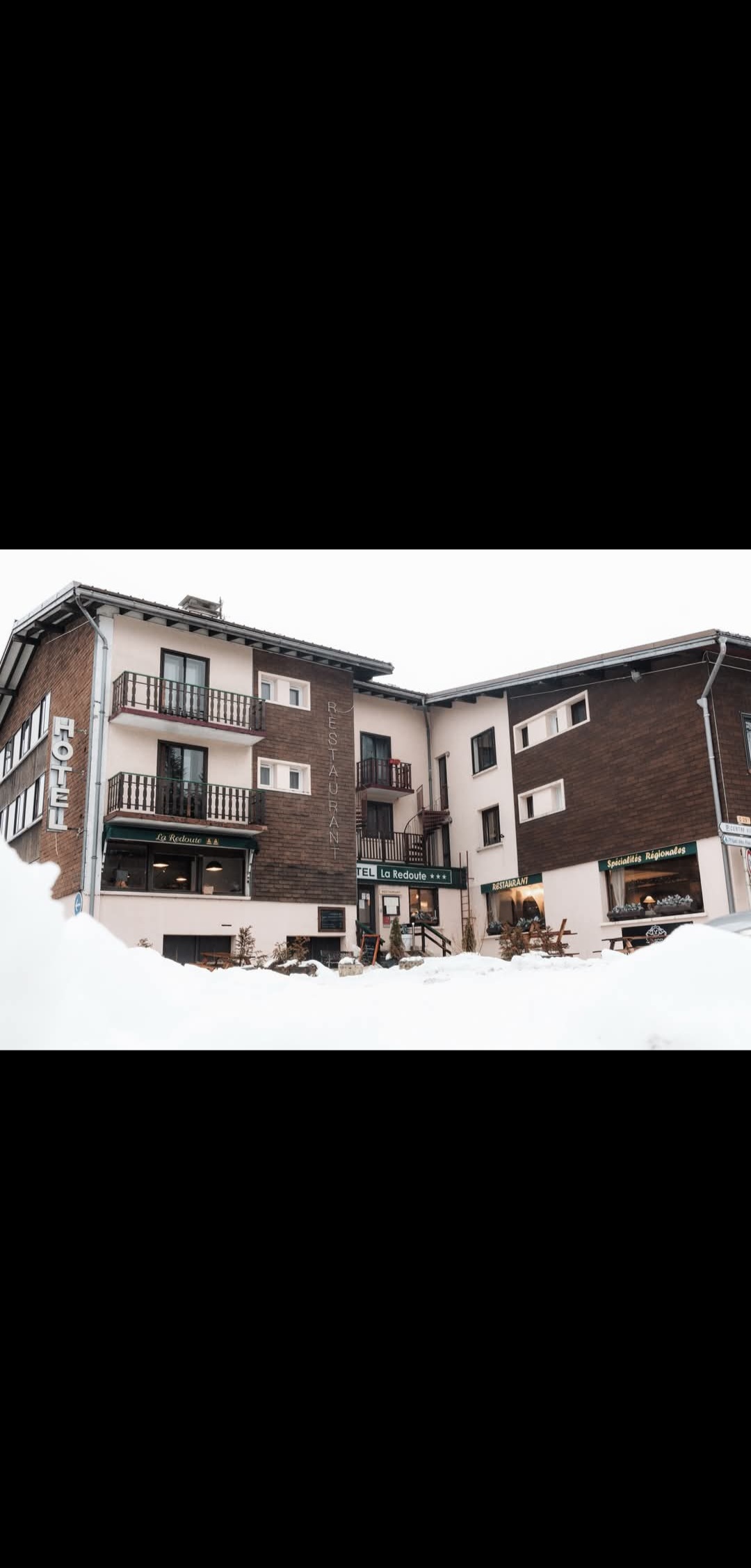
Hôtel La Redoute
Central village option, convenient for an evening walk and an early departure towards La Cure.
Review summary: Guests most consistently value the central location, friendly staff and straightforward mountain-hotel character. Scores are more modest for facilities and overall value, so treat it as the practical central choice rather than the premium one.
Exact-property photo not embedded — open Maps or Booking.com for current property images.
Hotel Restaurant LE YETI
Mountain hotel on the Geneva/Col de la Faucille side of Les Rousses, useful for riders who prefer easy road access.
Motorcycle note: The official Les Rousses listing states that a covered, enclosed garage is available for motorcycles and bicycles; reconfirm access when booking.
Review summary: Recent reviews point to cleanliness, helpful staff and the outlook on the edge of the village. The property is simpler than a resort hotel, but its location works well for this route.
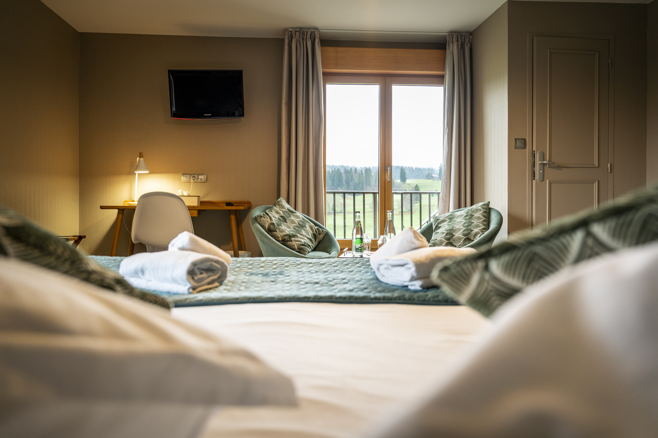
Domaine du Mont-Saint-Jean
Quieter 3-star option in the golf setting east of the village centre, with a more polished feel.
Review summary: Review scores are particularly strong for staff, cleanliness, comfort and location. This is the strongest-rated of the three Les Rousses options in the current Booking.com sample.
Where to eat
Jura specialities · meats on slate
Restaurant Le Refuge
Review summary: A very established village choice with a large review base. The local tourism listing specifically highlights Jura specialities and meats served on slate, making it a good fit for a regional dinner after Stage 1.
No verified direct online booking link found; confirm opening hours before riding.
Wine bar · local products · homemade cooking
Le 1107
Review summary: The official resort listing describes a central wine bar, restaurant and delicatessen focused on local products and homemade cooking. It suits riders wanting a less formal dinner with a strong local-produce angle.
No verified direct online booking link found; confirm opening hours before riding.
Jura cheese and meat specialities
Restaurant de la Fromagerie
Review summary: The official listing emphasises selected cheeses and meats, homemade desserts and artisanal ice creams. It is a compact, strongly regional choice rather than a generic brasserie stop.
No verified direct online booking link found; confirm opening hours before riding.
Local flavours and wines
Stage 1 is primarily Haut-Jura cheese country: look for Comté AOP, Morbier and Bleu de Gex. Les Rousses is also an excellent place to see Comté ageing culture at the Fort. Keep alcoholic tasting for after the motorcycle is parked.
Activities at destination
Guided visit of Fort des Rousses
A 1½-hour guided visit through the historic fort and its Comté ageing cellars. The operator currently requires online reservation; the interior stays around 8°C, so take an extra layer.
Lac des Rousses nautical base
Seasonal lake activity for a relaxed end of day: canoe, kayak, paddleboard and pedal-boat options are listed by the resort. Check current weather and opening before walking or riding out.
Golf du Domaine du Mont-Saint-Jean
An 18-hole mountain golf course with practice facilities; useful as an alternative activity if you are staying at the Domaine or extending the trip.
Arrival walking tour
Walking tour note: The stops are arranged in a logical progressive order within Les Rousses. Walking times are practical estimates and exclude visits. Once you know where you are staying, open the full route in Google Maps and adjust the starting point if needed.
- 1. Église Saint-Pierre des Rousses — start.
- 2. Mairie des Rousses — about 3 min / 170 m walking ↗.
- 3. Les Rousses Tourist Information Office — about 3 min / 220 m walking ↗.
- 4. Fort des Rousses — about 6 min / 460 m walking ↗.
Total: about 12 minutes / 850 m walking, excluding visits.
Open full walking route with all stops ↗Stage 2
Les Rousses → Bourg-en-Bresse
Distance174 km / 108 mi
Riding time4–4½ hr
DifficultyModerate
Stage 2 starts with the most obvious borderland character of the loop. From Les Rousses the road reaches Col de la Givrine and crosses into Switzerland before descending through Saint-Cergue and Gingins. The views broaden as altitude falls, with the Lake Geneva basin and the Alps appearing in clear conditions. Traffic can increase around the lower Swiss settlements and Divonne-les-Bains, so treat this section as a scenic transition rather than a fast one.
After Gex, the road changes completely. The climb to Col de la Faucille is one of the defining motorcycle sections of the route, followed by the high traverse to Mijoux and the descent towards Saint-Claude. The stacked bends around Lacets de Septmoncel reward accurate lines and patience with local traffic.
The return leg is lower but still engaging. Oyonnax leads to Montréal-la-Cluse, after which the route deliberately uses Col du Berthiand before descending to Poncin. The final kilometres through Pont-d'Ain are calmer, giving an easy run back into Bourg-en-Bresse and a useful contrast to the mountain riding earlier in the day.
Route sequence
Les Rousses → Col de la Givrine → Saint-Cergue → Gingins → Divonne-les-Bains → Gex → Col de la Faucille → Mijoux → Saint-Claude → Dortan → Oyonnax → Montréal-la-Cluse → Col du Berthiand → Poncin → Pont-d'Ain → Bourg-en-Bresse
POIs on this stage
The first cross-border high point of the day, carrying the road from the French Jura into Vaud.
Mountain village above Lake Geneva with broad Alpine views when the air is clear.
A compact Vaud village that marks the low point before the route turns back towards the French Jura.
Easy lakeside photo stop before the climb from the Pays de Gex begins.
The signature climb of Stage 2, with a succession of bends and, in clear weather, views towards Lake Geneva and Mont Blanc.
A classic high-Jura sequence of stacked bends on the descent towards Saint-Claude.
Dramatic limestone gorge close to the Saint-Claude section; best treated as an optional walking/photo detour.
Explains Oyonnax’s comb-making and plastics heritage, a distinctive industrial story on the return leg.
The protected road anchor that keeps the return on the more rewarding D85 rather than a faster lowland shortcut.
Route-side Bugey and Cerdon producer near Poncin. Visitor tasting/cellar options are offered by reservation; verify the current format and opening before making it a stop.
Historic river crossing and a natural final pause before the loop returns across the Bresse plain.
A fitting cultural finish if you did not visit before departure, and one of the region’s essential monuments.
Where to stay in Bourg-en-Bresse
Exact-property photo not embedded — open Maps or Booking.com for current property images.
Best Western Hôtel de France
Historic central hotel on Place Bernard, very convenient for the old town and a post-loop evening on foot.
Review summary: Current review evidence is strongest on central location, quietness and access to the historic centre. It is the most central of the three choices, while the older building means room impressions can vary.
Exact-property photo not embedded — open Maps or Booking.com for current property images.
Mercure Bourg En Bresse
Practical road-access option north-east of the centre, useful if easy arrival and departure matter more than being directly in the old town.
Review summary: Guests rate staff, cleanliness and comfort particularly well, and the property has a large current review base. It is a pragmatic final-night stop with straightforward vehicle access.
Exact-property photo not embedded — open Maps or Booking.com for current property images.
Cit'Hotel Logis De Brou
Close to the Royal Monastery of Brou and still walkable to the centre, giving a quieter base for the final night.
Motorcycle note: Current property information lists parking/garage options; confirm the exact secure motorcycle arrangement when booking.
Review summary: Current reviews score cleanliness, comfort, location and staff strongly. The combination of Brou access and a calmer setting makes it a useful compromise between sightseeing and easy road departure.
Where to eat
French · contemporary regional
Place Bernard
Review summary: Verified diner reviews score service and ambience especially well. The French menu and central location make it a strong final-evening choice after the loop.
Indian · Sri Lankan
Bollyfood
Review summary: A well-reviewed central alternative when you want something completely different from mountain and Bressan cuisine. The venue also maintains its own current reservation channel.
Thai · Cambodian
Saveurs d'Angkor
Review summary: TheFork diners rate the food and service above the ambience score, while the concept focuses on Thai and Cambodian cooking. It is a credible bookable alternative to a second French brasserie.
Local flavours and wines
The classic finish is Poulet de Bresse, supported by the rich dairy cooking of the Bresse. Near Poncin, Bugey Cerdon is the characteristic lightly sparkling rosé. If you visit a producer, schedule tasting only after the motorcycle is parked.
Activities at destination
Apothicairerie de l'Hôtel-Dieu guided visit
The preserved historic pharmacy is one of Bourg-en-Bresse’s distinctive small heritage visits. Check the current guided-tour timetable and reservation requirements before planning it for arrival day.
Royal Monastery of Brou
The flamboyant Gothic monastery is the city’s essential monument and works particularly well the next morning if Stage 2 arrives late.
Bourg-en-Bresse heritage walk / guided programme
The city programme regularly lists guided heritage visits and events around the historic centre. Use the current agenda to choose something compatible with your arrival time.
Arrival walking tour
Walking tour note: The stops are arranged in a logical progressive order, normally within approximately 1 km of the town centre. Walking times are practical estimates and exclude visits. Once you know where you are staying, open the full route in Google Maps and adjust the starting point or stop order to create the most convenient walk from your hotel.
- 1. Bourg-en-Bresse Tourist Office — start.
- 2. Co-Cathedral of Notre-Dame — about 5 min / 350 m walking ↗.
- 3. Porte des Jacobins — about 5 min / 350 m walking ↗.
- 4. Apothicairerie de l'Hôtel-Dieu — about 11 min / 800 m walking ↗.
- 5. Royal Monastery of Brou — about 5 min / 350 m walking ↗.
Total walking: about 26 min / 1.9 km, excluding visits.
Open full walking route with all stops ↗