Asia-Vientnam-5legsLoop
Send download link to:
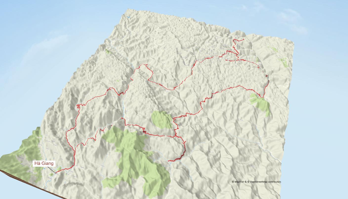
Hà Giang Karst Plateau Loop — 5 Leg TRACK
Hà Giang · Quan Ba · Yên Minh · Đồng Văn · Mèo Vạc · Du Già · Hà Giang
The Hà Giang Loop is one of Southeast Asia’s purest mountain rides: tight hairpins, single-lane terraces and huge karst scenery. This 5-leg TRACK keeps daily distances realistic, with 80–120 km easily filling a full day once you add photo stops, village traffic and viewpoints.
You start and finish in Hà Giang City, carving north through Quan Ba’s “Fairy Hills”, the high valleys around Yên Minh and the old streets of Đồng Văn before leaning your bike along the Ma Pi Leng Pass above the Nho Quế River. After a quieter homestay night in Du Già, you roll back to Hà Giang with memory cards full and tyres nicely scrubbed.
Nearest Airport(s)
Hà Nội · Nội Bài International Airport (HAN)
~300 km by road · 6–7 h transfer to Hà Giang City by bus, minibus or private car.
Hà Giang is not recommended as a first-ever ride in Vietnam: traffic rules are loose and mountain roads are unforgiving. Aim for at least intermediate experience on twisty roads before tackling this loop.
Track Overview
Total distance (loop): ~400 km · fully paved, often narrow and broken in places.
Typical daily riding time: 4–6 h per leg including photo stops and village traffic.
- Road type: steep mountain passes, terraces and village streets.
- Best season: October–April (cool/dry); avoid peak summer rains.
- Bike tip: 150–250 cc trail or light ADV with good engine braking, fresh tyres and brakes.
Leg-by-Leg Breakdown
Leave Hà Giang and climb straight into the karst. The Bac Sum and Quan Ba passes set the tone with long switchbacks, misty views and traffic that thins as you head north. Past Tam Sơn, the road snakes along pine ridges and terraces before dropping gently into the valley town of Yên Minh.
Open Leg 1 in Google MapsA superb mountain day: the climb out of Yên Minh runs through stone-walled fields to the S-bends of Thẩm Mã Pass, then on towards the Hmong villages around Phố Cáo. Old-town Đồng Văn makes a natural lunch stop before you push further north to Lũng Cú, Vietnam’s northernmost point, then loop back to sleep in Đồng Văn.
Open Leg 2 in Google MapsThe legendary leg. Distance is short but you will stop constantly: Ma Pi Leng hangs hundreds of metres above the Nho Quế River with endless views, tiny villages and sheer cliff faces. Ride slowly, enjoy the balconies and take your time rolling into Mèo Vạc towards late afternoon.
Open Leg 3 in Google MapsYou leave the sheer karst walls behind and slide into softer highlands. The road through Mậu Duệ twists through cornfields and scattered hamlets, with less traffic and more relaxed corners. Du Già is a classic loop village, with rice paddies, waterfalls and a handful of friendly homestays.
Open Leg 4 in Google MapsThe final leg flows back towards civilisation, with a mix of ridge-top sections and smoother valley roads. Take a last look at the Fairy Hills above Quan Ba, then drop steadily back to Hà Giang where most riders return bikes and transfer south to Hà Nội.
Open Leg 5 in Google MapsFood & Coffee Stops (Google Maps)
-
Banana Hostel & Cafe · Hà Giang
Easy pre-loop breakfast / coffee near several rental shops.
Open in Google Maps Hà Giang -
Chu Chu Pizza · Yên Minh
Popular carb stop with simple Western dishes and hot tea.
Open in Google Maps Yên Minh -
Cà phê Phố Cổ · Đồng Văn Old Quarter
Historic-house café overlooking the main square; perfect at sunset.
Open in Google Maps Đồng Văn -
Ma Pi Leng Panorama Café
Iconic balcony above the Nho Quế River on the pass itself.
Open in Google Maps Ma Pi Leng -
Nhà Hàng Cơm Phố Cổ · Mèo Vạc
Simple rice and noodle dishes; easy dinner choice in town.
Open in Google Maps Mèo Vạc -
Du Già BBQ & Beer
Casual village spot for grilled meats and cold beers after the ride.
Open in Google Maps Du Già
Suggested Overnight Bases (Booking.com)
-
Four Points by Sheraton Ha Giang ★★★★
Modern base in Hà Giang City with solid comfort and on-site parking; ideal pre- and post-loop nights. Check directly with the hotel for secure or covered motorbike parking options.
View on Booking.com Hà Giang · Leg 0 & 5 -
Laco Homestay (Đồng Văn area)
Character homestay in the karst region, popular with loop riders; usually offers simple rooms and space to park bikes inside the yard.
View on Booking.com Đồng Văn · Leg 2 -
Toto Chan Homestay (Mèo Vạc side)
Compact homestay used by many riders around Mèo Vạc and Ma Pi Leng; expect basic but friendly lodging and easy bike access.
View on Booking.com Mèo Vạc · Leg 3 -
Pả Chi Dùa Ecolodge · Du Già
Green valley setting with bungalows and village-style meals; good option to unwind after the twisty sections, with on-site parking area.
View on Booking.com Du Già · Leg 4
Always double-check current availability and parking conditions on the Booking.com listing or by contacting the property directly.
POI Photo Gallery · Hà Giang Loop


Photo credits: images from Wikimedia Commons (see captions for authors and licences). Used under CC BY-SA / public domain terms where applicable.