Chilean-LakeDistrictLoop-5Stages
Send download link to:
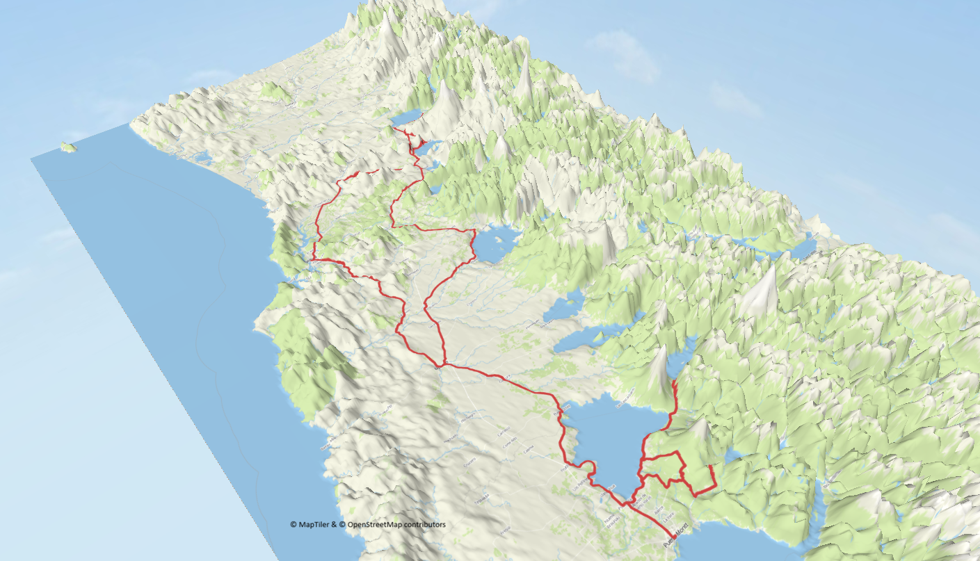
Chilean Lake District Loop · 5 Stages
Puerto Montt · Ensenada · Osorno · Panguipulli · Pucón · Villarrica · Lican Ray · Valdivia · format RTD
This Chilean Lake District Loop leaves and returns to Puerto Montt, using realistic Stage lengths in the 180–230 km band and linking genuine waypoints around Llanquihue, Todos los Santos and the inland volcanic corridor. The roadbook is built on known distances between key towns such as Osorno, Panguipulli, Pucón and Valdivia, then adjusted with short scenic detours.
Expect sealed roads throughout, a mix of fast highway links and slower lakeside sections, and continuous views of Osorno and Villarrica volcanoes. Overnight stops are all in established towns with fuel, food and accommodation, and each Stage card below includes a Google Maps route link plus waypoint-by-waypoint distances. The loop only closes back at Puerto Montt, in line with LUNAR rules.
Distances are approximate and rounded, based on current routing references between towns and landmarks rather than speculative numbers.
Nearest Airports
- Puerto Montt El Tepual Airport (PMC) – main gateway and closest to the start/finish.
- Temuco Airport (ZCO) – alternative for joining near Pucón / Villarrica.
Route Overview
Stages & Roadbook
Stage 1 · Puerto Montt → Ensenada (via Puerto Varas, Petrohué & Lago Chapo)
Leave Puerto Montt and follow the waterfront north towards Puerto Varas, where the first full panorama of Lake Llanquihue opens up beneath the snow-capped cone of Osorno. From here you trace the eastern shore towards Ensenada, then press on into Petrohué for views of Todos los Santos and the famous river falls before looping south-east to the quieter Lago Chapo backroads. You return to Ensenada for the night with the volcano now glowing in the evening light.
Waypoint distances (approx.):
- Puerto Montt → Puerto Varas · ~23 km
- Puerto Varas → Ensenada (Ruta 225) · ~46 km
- Ensenada → Petrohué · ~31 km
- Petrohué → Ensenada · ~31 km
- Ensenada → Lago Chapo · ~40 km
- Lago Chapo → Ensenada · ~40 km
- Budget · Hostal La Casona Ensenada – simple lakeside base with on-site parking.
- Mid · Topahue – country-style lodging with garden and free private parking.
- Premium · Entre Volcanes Lodge – cabins with lake views and secure guest parking.
- Mesa Tropera Ensenada – craft-beer pizzeria with lake views.
- Don Salmón – grilled fish and local dishes near the lakeshore.
- Todos los Santos Lake & Villa Peulla boat trip – Book activity
- Chiloé Island full-day excursion from Puerto Varas – Book activity

Author: Alejandro Zunino · CC BY-SA 4.0 · via Wikimedia Commons

Author: Jorge Morales Piderit · Public domain · via Wikimedia Commons
Stage 2 · Ensenada → Frutillar → Osorno
From Ensenada you backtrack a short stretch to Puerto Varas, then follow the western side of Lake Llanquihue towards Frutillar, with its German-influenced architecture and perfect postcard view of Osorno behind the theatre. You then descend to the Pan-American Highway and run south-east to Osorno, where you finish the day around the Plaza de Armas with secure hotel bases for the night.
Waypoint distances (approx.):
- Ensenada → Puerto Varas · ~46 km
- Puerto Varas → Frutillar (lakeside road) · ~67 km
- Frutillar → Osorno · ~70 km
- Budget · Hotel Mackenna – central location with basic rooms and on-site parking.
- Mid · Hotel Rucaitue – comfortable option near the square, private parking available.
- Premium · Sonesta Hotel Osorno – riverside complex with secure guest parking.
- Wufehr Restaurant – local specialities in the city centre.
- El Refugio – grilled meats and hearty portions popular with travellers.

Author: PameMV · CC BY-SA 3.0 · via Wikimedia Commons

Author: Manuel Cossu · CC BY-SA 3.0 · via Wikimedia Commons
Stage 3 · Osorno → Panguipulli → Pucón
Leaving Osorno you cut north-east through farmland and low hills towards Panguipulli, gateway to the Siete Lagos region. From there the road winds through temperate forest and lakeside scenery as you head for Pucón, with the unmistakeable cone of Villarrica volcano dominating the skyline as you roll into town.
Waypoint distances (approx.):
- Osorno → Panguipulli · ~146 km
- Panguipulli → Pucón · ~76 km
- Budget · Hotel El Coihue – central, simple and with free private parking.
- Mid · Alpes Hotel – close to the lakefront, good parking for motorbikes.
- Premium · Enjoy Pucón – resort-style hotel with spa and secure parking.
- Trawen – creative local cuisine just off the main street.
- La Magma – grill house popular with riders and hikers.

Author: Viajeros030 · CC BY-SA 4.0 · via Wikimedia Commons

Author: Kaworukoneru · CC BY-SA 4.0 · via Wikimedia Commons
Stage 4 · Pucón → Villarrica → Lican Ray → Valdivia
From Pucón you skirt along the southern shore of Lake Villarrica towards Villarrica, then turn south to the small resort of Lican Ray, on the shores of Lake Calafquén. The final stretch swings west through forests and farmland before dropping into riverside Valdivia with its busy waterfront and university vibe.
Waypoint distances (approx.):
- Pucón → Villarrica · ~27 km
- Villarrica → Lican Ray · ~30 km
- Lican Ray → Valdivia · ~136 km
- Budget · Villa del Río Express – straightforward stop with parking, easy access into town.
- Mid · Hotel Melillanca – central hotel with complimentary parking.
- Premium · Hotel Puerta del Sur – riverside setting and secure parking.
- La Perla del Sur – seafood-focused dining close to the river.
- Kunstmann brewery restaurant – beer hall with hearty plates.

Author: Draceane · CC BY-SA 4.0 · via Wikimedia Commons

Author: Kaworukoneru · CC BY-SA 4.0 · via Wikimedia Commons
Stage 5 · Valdivia → Osorno → Puerto Montt
Ride south-east from Valdivia to rejoin the main highway near Osorno, then sweep down to Puerto Montt with broad views towards the Reloncaví Sound. This final Stage is more about pace and flow, closing the loop while still giving you open horizons and time to reflect on the lakes and volcanoes behind you.
Waypoint distances (approx.):
- Valdivia → Osorno · ~125 km
- Osorno → Puerto Montt · ~100 km
- Budget · Hotel Antupiren – rider-friendly budget choice with parking available.
- Mid · Hotel Apart Colón – serviced units on the waterfront with private parking.
- Premium · Novotel Puerto Montt – modern 4-star with secure on-site parking.
- Club Alemán – classic stop with hearty dishes near the centre.
- Fogón del Leñador – grilled meats and local specialities.

Author: Nathan Hughes Hamilton · CC BY-SA 2.0 · via Wikimedia Commons

Author: Kaworukoneru · CC BY-SA 4.0 · via Wikimedia Commons