

Route 137: Taranaki Forgotten World Loop
Ride a five-stage, 1,084.7 km / 674 mi motorcycle loop from New Plymouth across the Forgotten World Highway, central North Island and Hawke’s Bay, returning along the Taranaki coast.
Route area: New Zealand.
This legacy EMJ route remains part of the motorcycle-route archive. Content and downloadable files should be used as trip-planning guidance and checked against current road conditions, weather, access rules, opening times and local restrictions before riding.
Route 137: Taranaki Forgotten World Loop
A five-day motorcycle circuit from New Plymouth across the remote Forgotten World Highway, the volcanic central plateau and Hawke’s Bay, then south through Manawatū and back along the Taranaki coast.
Loop · same start and finish
1,084.7 km / 674 mi
5 riding stages
New Plymouth
Taumarunui · Napier · Palmerston North · Whanganui
The complete loop at a glance
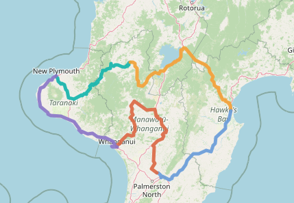
Five coloured riding stages trace the loop from New Plymouth and back.
A North Island loop with changing road character
The Taranaki Forgotten World Loop starts and finishes in New Plymouth, linking the west coast with the central North Island, Hawke’s Bay and Manawatū over 1,084.7 km / 674 mi. The route changes from dairy country beneath Taranaki Maunga to the narrow, winding back-country road of SH43. The Forgotten World Highway, with its historic settlements, saddles and tunnel country, is a defining part of the ride; services are limited, so fuel and food need planning before leaving the larger towns.
Beyond Taumarunui, the itinerary crosses the volcanic landscape around Taupō before reaching Napier and the produce-growing plains of Hawke’s Bay. It then turns through Palmerston North and Whanganui to the coast. The final section uses Surf Highway 45, where sea exposure and changing weather can shape the day as much as the bends.
Expect a varied touring rhythm rather than five identical days: remote winding highway, open plateau roads, town approaches and coastal riding. The overnight bases are Taumarunui, Napier, Palmerston North and Whanganui. Keep sightseeing visits separate from the riding schedule, especially on longer days. Check weather, daylight, fuel hours and current road notices before each departure; NZTA reports maintenance and occasional closures on SH43. November to March is the broad preferred period in this roadbook, while shoulder-season travel calls for closer checks of conditions and opening arrangements. Choose a stage below for full riding notes, services, places to stay, food, culture and the short destination walk.
Explore the route day by day
New Plymouth → Taumarunui
Leave the Taranaki plains for the SH43 Forgotten World Highway, with remote saddles, historic settlements and the Moki Tunnel corridor.
Taumarunui → Napier
Ride east through the central plateau and Taupō district before descending towards the Hawke’s Bay coast.
Napier → Palmerston North
Cross Hawke’s Bay inland through Waipawa and Dannevirke, then continue towards the Manawatū.
Palmerston North → Whanganui
Turn north-west through the central ranges and volcanic plateau corridor before reaching the Whanganui River city.
Whanganui → New Plymouth
Return along the west coast and Surf Highway 45, closing the loop beneath Mount Taranaki.
Prepare for remote and changing conditions
- Road character: paved touring route with narrow, winding country sections on SH43 and exposed coastal stretches.
- Fuel and food: refuel before the remote SH43 corridor; confirm station hours and carry water and food for service gaps.
- Conditions: check the NZTA Journey Planner and MetService before setting out. Works, slips, flooding, wind and visibility can affect the route.
- Navigation: save the route and an offline map area where your navigation app supports it. Compare any imported or recalculated route with the EMJ route map.
- Arrival: allow separate time for museums, cellar visits and longer walks; confirm accommodation check-in and motorcycle parking directly.
SH43 is a back-country journey with limited alternatives. Check live notices and closures before departure, and be ready to change the plan if weather or road conditions deteriorate.
The Forgotten World Highway is the ride to savour
The 155 km / 96 mi SH43 from Stratford to Taumarunui is Route 137’s defining motorcycle road. Four saddles, the Moki Tunnel and the Tāngarākau Gorge carry the ride from Taranaki’s volcanic ring plain into steep, forested valleys and open back-country. The appeal is the changing rhythm of bends, climbs and descents; ride for clear sightlines and a steady pace, not an arrival target.
Rider’s checklist
- Fill up before Stratford and plan the next refuel in Taumarunui; do not count on a fuel stop along SH43.
- NZTA lists sealing the final 12 km through Tāngarākau Gorge among completed improvements. Maintenance and stop/go controls can still affect progress, so check the NZTA Journey Planner before setting out.
- Carry water and food for the remote stretch, and use signed pull-offs rather than narrow shoulders or tunnel approaches for stops.
Explore the Stratford–Taumarunui Heritage Trail · read CampingApp’s camper-focused Taranaki guide.
Landscapes and places that shape the ride
Forgotten World Highway
SH43 threads through remote hill country, historic settlements and the Moki Tunnel landscape. Its quieter character rewards a patient pace and advance fuel planning.
Volcanic central plateau
The route moves inland around Taupō and the volcanic plateau, where open views and changing elevation contrast with the sheltered Taranaki dairy plains.
Napier and Hawke’s Bay
Napier’s Art Deco streets and the region’s food and wine country add a strong cultural and culinary counterpoint to the highway days.
Taranaki coast
Surf Highway 45 brings the return leg back towards New Plymouth, with open coastal scenery and views towards Taranaki Maunga when conditions are clear.
Your route on a compatible device or map
Use only the navigation files actually supplied with your roadbook download. Extract a ZIP first if the files arrive in an archive. Import the chosen file into a compatible device or app, then compare the result with the EMJ map: a device may recalculate the route and change the roads.
GPX
GPX can contain route or track data for compatible navigation devices and apps. Check which GPX mode your device supports, then review the imported line before riding.
ITN
ITN is TomTom’s itinerary format on compatible devices. MyRoute-app Routeplanner also documents ITN import/export. Confirm your model’s support and inspect the resulting route.
MyRoute-app format guidance ↗ · TomTom GPX and ITN information ↗
KML / KMZ
KML and compressed KMZ files are useful for viewing or exploring a route in Google Earth and compatible mapping software. They do not automatically provide turn-by-turn road navigation.
The route roadbook and navigation downloads require a free EMJ Rider account. Check the roadbook download area for the exact formats included.
A possible road-trip inspiration
This motorcycle itinerary may also inspire a car journey, but the full route has not been verified here for every car, rental agreement or access restriction. Before driving it, check current road notices, vehicle restrictions, road conditions and the terms of your rental; do not assume every road or attraction permits every vehicle.
Frequently asked questions
Is Route 137 a loop?
Yes. It starts and finishes in New Plymouth, with four overnight stops at Taumarunui, Napier, Palmerston North and Whanganui.
How long is the route?
The five riding stages cover approximately 1,084.7 km / 674 mi. Stage figures and riding estimates are in the full roadbook.
When should I ride it?
The roadbook gives November to March as the broad preferred period. Check current weather, daylight and NZTA notices for SH43 and the coastal sections before every Stage.
Which navigation files are included?
Sign in to the free EMJ Rider Area and check the Route 137 download area for the exact files supplied. Import only a format supported by your device and compare the result with the EMJ map.
Do I need an account for the complete roadbook?
Yes. A free EMJ Rider account is required for the full interactive and printable roadbook.
Plan the Taranaki Forgotten World Loop
Open the full roadbook for stage-by-stage riding intelligence, services, accommodation, food, cultural attractions and the destination walks.
Open the complete roadbook ↗